What is a Resource Protection Area?
By Kory Kreiseder, Urban Conservation Specialist and Home Turf Coordinator, Northern Virginia Soil and Water Conservation District
This year I have been working with the FCMGA Home Turf program. Home Turf facilitates soil testing for clients, assesses weeds and, most important, provides environmentally sound nutrient management plans to guide homeowners in the application of fertilizer, lime and compost to their lawns.
The Home Turf season for 2016 ended in September, but the season for lawn fertilization extends through October and November. I want to make sure that all readers of fairfaxgardening.org, not just the participants in Home Turf, are aware of the importance of Resource Protection Areas (RPAs), what should be planted there, and considerations in applying fertilizer in these environmentally sensitive areas.
Fairfax County is adjacent to the tidal portion of the Potomac River. It is within the Virginia-designated Chesapeake Bay Preservation Area. This designation establishes RPAs around specific water features to safeguard the quality of our local water bodies, the Potomac River, and ultimately the Chesapeake Bay.
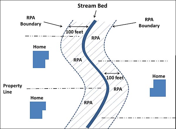
A typical Resource Protection Area configuration on properties adjacent to a stream.
RPAs are a minimum of 100 feet in width and include land on one or both sides of one or more of the following features:
- A tidal wetland, such as Dyke Marsh,
- Tidal shorelines, such as the Potomac and Occoquan rivers and their embayments,
- A water body with perennial flow (flows continuously throughout the year), including most named streams in Fairfax County,
- A non-tidal wetland connected by surface flow and contiguous to a tidal wetland or water body with perennial flow, often found in wooded floodplains,
- A buffer area that includes any land within a major floodplain or any land within 100 feet of a feature listed in 1 through 4.
How do I know if my property contains an RPA?
When RPAs were established in 1993 and expanded in 2003, property owners were informed in writing of the existence of an RPA on their property. The letter on RPAs should have been transferred along with the title when the property was sold. If there are no streams or other bodies of water near your property, it is safe to assume you do not have an RPA. However, if there are streams or wetlands near your home, it is wise to check Fairfax County’s Digital Map Viewer and choose the Chesapeake Bay Preservation Areas map. Find your property, and the RPA, if you have one, will be outlined on the map.

Little Pimmet Run after stream restoration. Notice unmown grasses and other vegetation added to a Resource Protection Area along the streambed.
If your property has an RPA it is best to leave it as natural as possible and avoid the application of fertilizers and pesticides to the extent practical. The Northern Virginia Soil and Water Conservation District recommends restoring the RPA with native trees, shrubs and perennials, as these plants do not require any fertilizer or pesticides.
Resources
FAQs: Resource Protection Areas, Fairfax County
Plant NoVa Natives
Designation of Resource Protection Area, Fairfax County
edited 2020